














 Mean Stack Development
 Vue JS Development
 Javascript Development
 React JS Development
 Angular JS Development
 Next JS development
 Java Development
 Python Development
 Django Development
 Cherrypy Development
 C# Development
 ASP.NET Development
 NodeJS Development
 Laravel Development
 CodeIgniter Development
 Zend Development
 Ruby on Rails Development
 CakePHP Development
 PHP Website Development
 Symfony Development
 Drupal Development
 Joomla Development
 Wordpress Development
 .NET Nuke Development
 Kentico
 Umbraco
 .NET MAUI Development
 Xamarin Application Development
 iOS Application Development
 Android Application Development
 Android Wear App Development
 Ionic Development
 iBeacon Application Development
 Universal Windows Platform (UWP)
 Kotlin Application Development
 Swift Application Development
 Flutter Application Development
 PWA Application Development
 Flutter Health Tech & Wearable App Development Company
 React Native Health Tech Wearable App Development
 Offshore Software Development
 Custom Application Development
 Front-End Development
 Full Stack Development
 AI & Machine Learning
 Custom CRM Solutions
 Flask Software Development
 Electron JS Development
 ChatGPT Development
 Telemedicine App Development
 Build Smart Telemedicine Platform
 Beauty & Salon App Solutions
 Hire Workato Experts
 Magento Development
 Magento 2.0 Development
 Magento Enterprise
 Shopping Cart Development
 Prestashop Development
 Shopify Development
 Open Cart Development
 WooCommerce Development
 BigCommerce Development
 NopCommerce Development
 Virto Commerce Development
 AspDotNetStorefront Development
 .NET Application Development
 Microsoft Dynamics CRM
 VB .NET Development
 Sharepoint Migration
 ASP.NET Core Development
 ASP.NET MVC Development
 AJAX Development
 Agile Development
 Microsoft Bot
 Microsoft Blazor
 Microsoft Azure Cognitive
 HTML 5
 UI/UX Design
 Graphic Design
 Adobe Photoshop
 XML Application Development
 Cloud Computing Solutions
 Azure Cloud App Development
 AWS Development
 Google Cloud Development
 Certified AWS IoT Services Developers
 DevOps Consulting & Development
 Kubernetes Consulting & Services
 SQL Programming Development
 MySQL Development
 MongoDB Development
 Big Data
 Robotic Process Automation
 Social Media Marketing
 Search Engine Optimization
 QA Testing
 Software Testing
 Software Security
 Maintenance And Support
 I.T. Consulting Services
 Business Intelligence
 YII Development
 Data Analysis
 Alexa Skills Development
 On Demand App for Mobile repairing services
 On Demand App for Car Service Booking
 On Demand App for Cleaning Services
 On Demand App for Pharmacy
 On Demand Dedicated Developers
 On Demand Lawyer App Development









 Nuki Smart Lock
 Salto Smart Lock
 TTlock Smart Lock
 NFC App Development
 Custom IOT Enabled Smart Lock
 Smart Locker Solutions
 Hospital Smart Lock Systems
 Hotel Smart Lock Systems
 Smart Home & Office Locks
 Smart Access for Schools & Colleges
 Unloc Smart Lock Integration
 Yale & August Smart Lock Integration
 Populife Smart Lock Integration
 Smart Lock Hardware Development
 Dairy IoT Solutions
 Agri IoT & AI Solutions
 Weather & Climate Solutions
 Water & Waste Management Solutions
 RaspBerry Pi
 Firmware Software Development
 ESP 32 Software Development
 Embedded Development
 Internet of Things
 Smart IoT Development
 IoT Sensor Integration & Development Solutions
 Smart IoT System Development for HVAC
 Tuya IoT App Development
 Particle IoT SDK
 IoT Development with AI
 Smart Pet GPS Tracker
 Dairy GPS Tracking Solutions
 GPS Fleet Management Software
 Car Rental & Subscription Solutions
 Car Buy & Sell Marketplace Development
 AI-Powered Car Wash App Development
 PCB Design & Fabrication
 IoT AC Automation
 AI–IoT Painting Solutions
 IoT Wearable Hardware & App Development
 HVAC Automation & AI Control Systems
 Smart Home IoT Engineering
 AI Embedded Systems
 AI Hardware Design Service
 Advanced IoT Hardware & Firmware Development
 Device Driver Development Services
 NXP i.MX RT Firmware & Hardware Services
 Microchip PIC & AVR Development
 Hire IoT Architects
 IoT Cloud & Infrastructure Solutions
 Infineon XMC / AURIX Development Services
 Matter & Thread IoT Services
 Native IoT Mobile App Development (BLE & Wi-Fi)
 Snapdragon IoT Firmware Development
 Renesas RA/RX Firmware Services
 Silicon Labs EFR32 Development Services
 Smart Wearable App Development
 Smart IoT Meters
 Smart Healthcare Wearable App Development
 Health Care Monitoring System
 Fitness Tracking App Development
 Smart Home Automation Apps
 nRF PCB Design
 ESP32 PCB Design
 Embedded Wearables Engineers
 Rental Property Management System
 Building Management System
 Smart Lighting Development
 Infineon Semiconductor Firmware Development Services
 Custom Camera Development: Hardware, Firmware & PCB Prototyping
 Smart Security Camera SDK
 Nordic Semiconductor SDK
 Infineon SDK
 Arduino SDK
 NFC Lock Integration
 Kerong Lock Integration
 IoT & AI Solutions for Manufacturing
 Smart Inventory & Logistics Solution
 Food & Beverage Industry Solutions
 Smart Hospitality Solutions
 Smart Property Management
 Custom Smart Home IOT SDK
 Smart IoT & AI in Healthcare
 AI-Powered Security Solutions
 Smart Home Safety & AI
 Veterinary Clinic Management (AI)
 Pet Care System (AI & IoT)
 Pet Training & Adoption (AI)
 Healthcare IoT Development
 Event Management Software
 Money Remittance App
 Money Lending App Development
 Utility and Bill Payment App
 IoT Mobile App Development (Flutter & React Native)
 AI & IoT Retail Solutions
 Smart EV App Development
 Smart Solar IoT & AI Solutions
 IoT-Based Energy Systems
 Smart Energy & Utilities Solutions
 6G Solutions
 IoT Security Solutions
 AI-Powered Lottery App Development
 AI-Sports Fitness Club Management
 Travel
 Real Estate
 Medical & Healthcare
 e-Learning
 Consumer Products
 Finance
 Automobile
 Media & Entertainment
 Billing Software
 Enterprise Resource Planning (ERP)
 Augumented & Virtual Reality
 Point of Sale(POS) Development
 Learning Management System
 EV Charging Solutions
 About Us
 Partners & Certifications
 Quality Assurance
 Our Clients & Testimonials
 Development Process
 Our Products
 Social Responsibility
 Work Ethics
 Vision & Mission
 Awards
 Live Project Demos
 Contact Us
 Case Studies
 Portfolio
 Blog
Blog
Wearable GPS & Indoor Positioning Development Services
Adequate Infosoft develops wearable location systems for outdoor routes, buildings and transition zones. Our services cover GNSS/GPS hardware, PCB and antennas, firmware, BLE positioning, Wi-Fi and cellular location, UWB, sensor fusion, apps, cloud maps, geofences and alerts.
The right solution is rarely "GPS everywhere." Satellite signals weaken indoors, while indoor technologies need anchors, radio maps, gateways or compatible phones.
We design around the real requirement: wide-area tracking, room presence, caregiver proximity, distance and direction, or a reliable last-known emergency position.
Let's Work Together!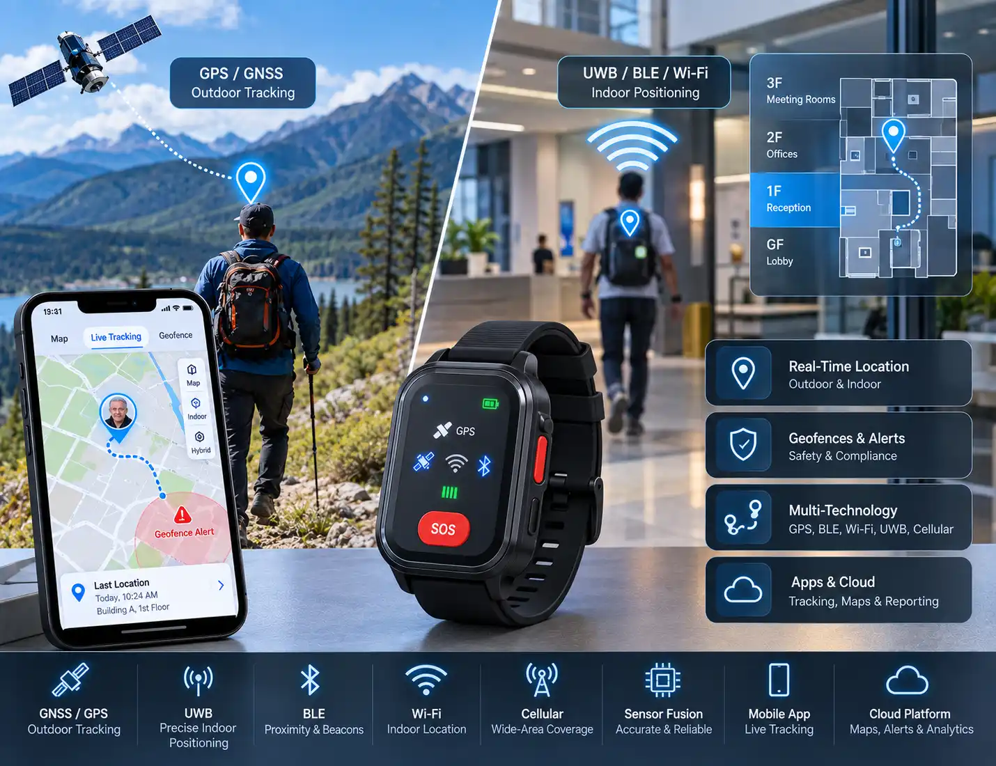
What's Wearable GPS and Indoor Positioning Development?
Wearable positioning development implies development of hardware, firmware as well as software that provides the estimations of position, movement and certainty.
System for outdoor uses GNSS, phone GPS or assisted GNSS. Indoor systems can rely on BLE beacons, direction finding technology, UWB, Wi-Fi, surrounded sensors or locations used for check-in.
None of the systems can provide the same accuracy, power consumption and coverage. GPS.gov claims that accuracy is influenced by geometry, blockage, reflections, atmosphere and the type of receiver.
Therefore, working systems needs plenty of backups, dealing with uncertainty and field validation rather than relying on capabilities of a chip.
Choosing the Right Positioning Technology
GNSS for Outdoor Positioning
GNSS technology offers information related to latitude, longitude, speed as well as timing without requiring any type of infrastructure.
GNSS technology offers information related to latitude, longitude, speed as well as timing without requiring any type of infrastructure. We integrate receivers or cellular SSPs, antennas, low noise power supply, assistance data, and firmware for cold/angular fixings.
The support from the constellation varies depending on external parameters like the receiver and target market.
The design process must indicate the body shadowing, enclosure tuning, multipath information, fix time, and the energy per location. Using the Assisted GNSS technology may reduce acquisition efforts and costs. The information about the position of a mobile phone may help in reducing the costs and energy consumption of wearable devices.
BLE proximity and RSSI zones
BLE advertising supports proximity and zone-level systems. Gateways observe identifiers and signal strength, then a backend estimates whether the wearer is near a room or department.
BLE advertising supports proximity and zone-level systems. Gateways observe identifiers and signal strength, then a backend estimates whether the wearer is near a room or department. RSSI changes with walls, people, orientation and congestion, so it is not precise ranging.
We design beacon intervals, transmit power, gateway placement, identity rotation and calibration. Our wearable IoT device development services connect radio design with firmware, applications and cloud operations.
Bluetooth Direction Finding and Channel Sounding
Bluetooth Direction Finding provides angle of arrival(AoA) or angle of departure(AoD) information. The usual procedure involves fixed-location antenna arrays and a transmitter in the wearable.
Bluetooth Direction Finding provides angle of arrival(AoA) or angle of departure(AoD) information. The usual procedure involves fixed-location antenna arrays and a transmitter in the wearable.
However, in the latter case, AoD must be considered since the role of transmitter and receiver is reversed. The level of performance relies upon antenna design, calibration, reflections, infrastructure, and algorithms.
Bluetooth Channel Sounding employs phase-based time of flight and round-trip measurements. It can be used together with RSSI or Direction Finding.
However, it is important to ensure that the specific device and operating system support the technology, Bluetooth versions alone are not a guarantee of obtaining necessary positioning functions.
UWB for distance and direction
UWB suits precise short-range distance or direction. Systems may use fixed anchors or a compatible phone for "find nearby" guidance.
UWB suits precise short-range distance or direction. Systems may use fixed anchors or a compatible phone for "find nearby" guidance. Apple Nearby Interaction supports compatible devices and accessories subject to hardware and protocol requirements.
UWB adds radio cost, power and complexity. We assess coexistence, antenna placement, anchor geometry, update rate and phone compatibility.
Wi-Fi, cellular and sensor-fusion fallbacks
Wi-Fi positioning uses visible access points or existing ranging facilities. Cellular positioning provides easier means for determining location but with lower accuracy.
Wi-Fi positioning uses visible access points or existing ranging facilities. Cellular positioning provides easier means for determining location but with lower accuracy. Every event needs to contain the method used, timestamp, estimation of accuracy, and confidence.
Using IMUs, magnetometers, and barometers is also an option for filling in the gaps, but errors accumulate. Maps and radio methods correct them.
Relevant Adequate Infosoft Case Studies
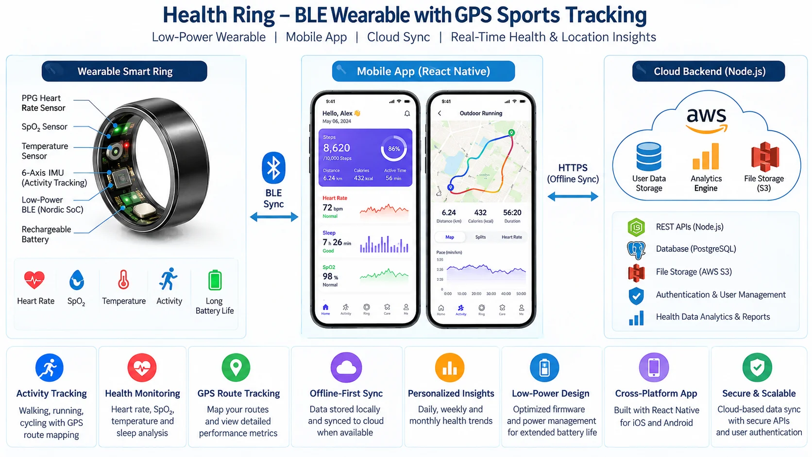
Health Ring app with GPS sports-route tracking
The Health Ring wearable app case study used React Native and Node.js for a BLE smart ring.
Phone GPS mapped walking, running and cycling while ring data synchronized locally and to cloud services. Offline-first workflows joined a low-power wearable with the phone's location subsystem.
Read Case Study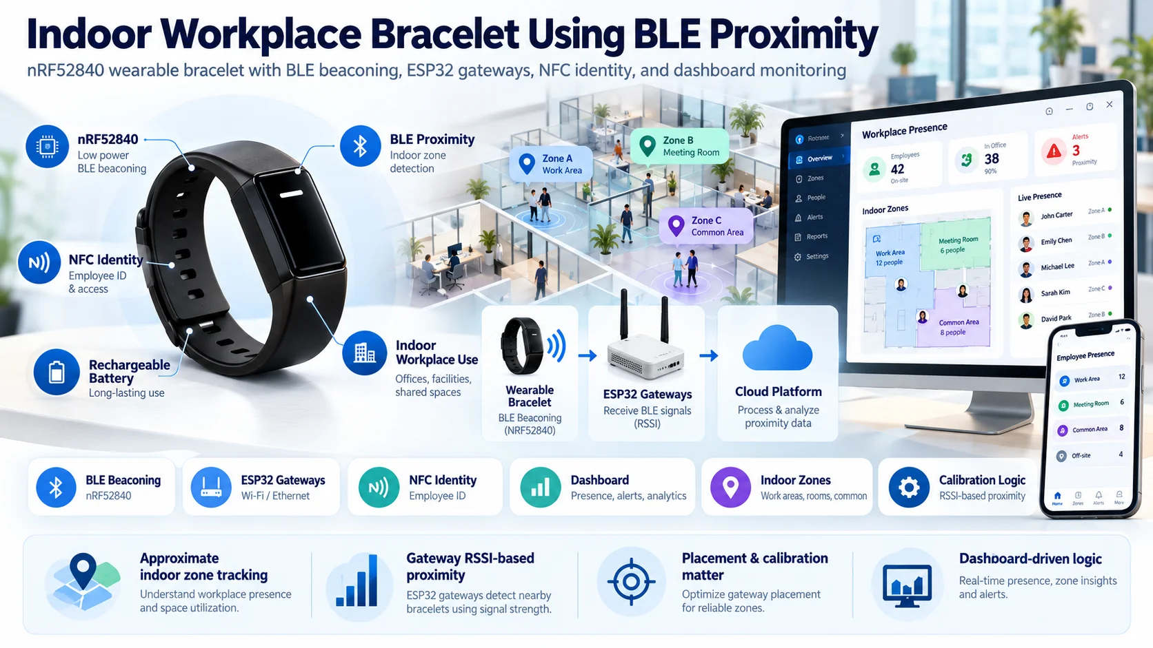
Indoor workplace bracelet using BLE proximity
Our IoT wearable bracelet case study combined nRF52840, BLE beaconing, ESP32 gateways, NFC identity and a dashboard.
Gateway RSSI supported approximate indoor zones, demonstrating the need for placement, calibration and dashboard logic rather than treating RSSI as coordinates.
Read Case Study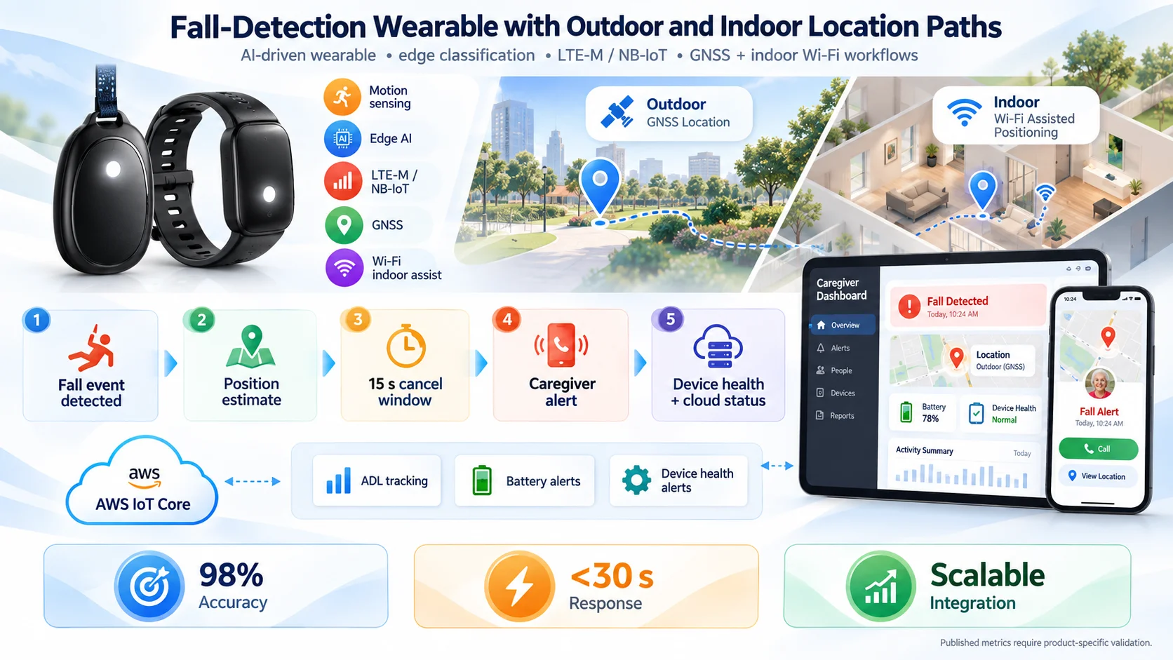
Fall-detection wearable with outdoor and indoor location paths
The AI-driven fall-detection wearable case study combined motion sensing, edge classification, LTE-M/NB-IoT, GNSS and Wi-Fi-assisted indoor workflows.
It connects an event, position estimate, cancellation period, caregiver alert and device health. Published metrics require product-specific validation.
Read Case StudyEnd-to-End Wearable Positioning Engineering
Specification and site assessment
The element responsible for evaluation is the area, frequencies of updates, the degree of uncertainty, reaction time, privacy roles, battery and offline behavior.
The element responsible for evaluation is the area, frequencies of updates, the degree of uncertainty, reaction time, privacy roles, battery and offline behavior.
A project taking place indoors requires a scheme of the premise, electromagnetic conditions, power supply and networking specifications. The assessment of the area will provide the information about multipath, coverage gaps and number of stations.
PCB, antenna and enclosure development
Multiple radios compete for area inside a body-worn enclosure. Batteries, skin and metal can detune antennas. Our wearable PCB design and prototyping team handles RF layout, antennas, power, charging and enclosure-aware prototypes.
Multiple radios compete for area inside a body-worn enclosure. Batteries, skin and metal can detune antennas. Our wearable PCB design and prototyping team handles RF layout, antennas, power, charging and enclosure-aware prototypes.
Final behavior is measured on assembled devices.
Firmware and optimization of power
Firmware conduct fixes and shows ads, does scans, uses sensors, transfers data and puts in sleep. Policies can adapt by raising the frequency in an SOS situation, when in motion and while coming close to a boundary, and lowering the frequency otherwise.
Firmware conduct fixes and shows ads, does scans, uses sensors, transfers data and puts in sleep. Policies can adapt by raising the frequency in an SOS situation, when in motion and while coming close to a boundary, and lowering the frequency otherwise.
Buffering provides off-line data storage for timestamps and sequence numbers, which enables you to tell the difference between past-data and live coordinates. Battery testing includes routes, buildings, areas with weak signals and effort.
Mobile, cloud and mapping applications
Applications pair devices, request permissions, display routes or floor plans and label positions as live, approximate or stale. Our healthcare wearable app development services cover BLE synchronization, background operation, caregiver workflows and cloud integration.
Applications pair devices, request permissions, display routes or floor plans and label positions as live, approximate or stale. Our healthcare wearable app development services cover BLE synchronization, background operation, caregiver workflows and cloud integration.
Cloud services manage identities, geofences, alerts, location history, maps, battery state, gateways and firmware. Raw observations remain separate from calculated positions so algorithms can improve without losing evidence.
Privacy, Security and Responsible Location Use
Wearable devices used to track locations can disclose information about the home environment, medical appointments or health-related visits, and patterns of normal activities.
The company has policies in place that include the principles of data minimization, user consent, role-based access, encrypting of data, conducting audit logs, and deciding on data retention period.
Emergency access should be tightly controlled and monitored. The system designs may use authenticated devices, every time change id credentials, unique id's and signed firmware.
It is essential to verify that all healthcare, employment, and child-safety solutions meet legal criteria, as not simply using safeguards will suffice for compliance with HIPAA, GDPR, or medical equipment.
Frequently Asked Questions
Indoors, the accuracy tends to lessen widely. Reliable solutions use another technique or mention the result as approximate instead of suggesting continuous GPS accuracy.
With the help of BLE gateways, zones can be created with a minimum cost. On the other hand, better precision can be achieved by using Direction Finding or UWB. The technology will depend on accuracy, infrastructure, power supply, compatibility, and budget.
Yes. It can combine onboard GNSS with LTE-M, NB-IoT or another wide-area link. Independent tracking increases hardware, antenna, subscription and power requirements. Phone-assisted designs can be smaller but fail when the phone is absent or permissions are unavailable.
Accuracy must be expressed for a defined environment, percentile and test method. Open-sky GNSS, indoor RSSI zones, UWB ranging and inertial estimates are not directly comparable. We establish acceptance criteria and report measured error distributions rather than promising one universal number.
Absolutely. However, the solution must contain certain parameters like delays, fixes, boundaries, the number of retries, and an SOS signal in the vicinity in case the cloud connection is lost.
Editorial Sources