








 Mean Stack Development
 Vue JS Development
 Javascript Development
 React JS Development
 Angular JS Development
 Next JS development
 Java Development
 Python Development
 Django Development
 Cherrypy Development
 C# Development
 ASP.NET Development
 NodeJS Development
 Laravel Development
 CodeIgniter Development
 Zend Development
 Ruby on Rails Development
 CakePHP Development
 PHP Website Development
 Symfony Development
 Drupal Development
 Joomla Development
 Wordpress Development
 .NET Nuke Development
 Kentico
 Umbraco
 .NET MAUI Development
 Xamarin Application Development
 iOS Application Development
 Android Application Development
 Android Wear App Development
 Ionic Development
 iBeacon Application Development
 Universal Windows Platform (UWP)
 Kotlin Application Development
 Swift Application Development
 Flutter Application Development
 PWA Application Development
 Flutter Health Tech & Wearable App Development Company
 React Native Health Tech Wearable App Development
 Offshore Software Development
 Custom Application Development
 Front-End Development
 Full Stack Development
 AI & Machine Learning
 Custom CRM Solutions
 Flask Software Development
 Electron JS Development
 ChatGPT Development
 Telemedicine App Development
 Build Smart Telemedicine Platform
 Beauty & Salon App Solutions
 Hire Workato Experts
 Magento Development
 Magento 2.0 Development
 Magento Enterprise
 Shopping Cart Development
 Prestashop Development
 Shopify Development
 Open Cart Development
 WooCommerce Development
 BigCommerce Development
 NopCommerce Development
 Virto Commerce Development
 AspDotNetStorefront Development
 .NET Application Development
 Microsoft Dynamics CRM
 VB .NET Development
 Sharepoint Migration
 ASP.NET Core Development
 ASP.NET MVC Development
 AJAX Development
 Agile Development
 Microsoft Bot
 Microsoft Blazor
 Microsoft Azure Cognitive
 HTML 5
 UI/UX Design
 Graphic Design
 Adobe Photoshop
 XML Application Development
 Cloud Computing Solutions
 Azure Cloud App Development
 AWS Development
 Google Cloud Development
 Certified AWS IoT Services Developers
 DevOps Consulting & Development
 Kubernetes Consulting & Services
 SQL Programming Development
 MySQL Development
 MongoDB Development
 Big Data
 Robotic Process Automation
 Social Media Marketing
 Search Engine Optimization
 QA Testing
 Software Testing
 Software Security
 Maintenance And Support
 I.T. Consulting Services
 Business Intelligence
 YII Development
 Data Analysis
 Alexa Skills Development
 On Demand App for Mobile repairing services
 On Demand App for Car Service Booking
 On Demand App for Cleaning Services
 On Demand App for Pharmacy
 On Demand Dedicated Developers
 On Demand Lawyer App Development







 Nuki Smart Lock
 Salto Smart Lock
 TTlock Smart Lock
 NFC App Development
 Custom IOT Enabled Smart Lock
 Smart Locker Solutions
 Hospital Smart Lock Systems
 Hotel Smart Lock Systems
 Smart Home & Office Locks
 Smart Access for Schools & Colleges
 Unloc Smart Lock Integration
 Yale & August Smart Lock Integration
 Populife Smart Lock Integration
 Smart Lock Hardware Development
 Dairy IoT Solutions
 Agri IoT & AI Solutions
 Weather & Climate Solutions
 Water & Waste Management Solutions
 RaspBerry Pi
 Firmware Software Development
 ESP 32 Software Development
 Embedded Development
 Internet of Things
 Smart IoT Development
 IoT Sensor Integration & Development Solutions
 Smart IoT System Development for HVAC
 Tuya IoT App Development
 Particle IoT SDK
 IoT Development with AI
 Smart Pet GPS Tracker
 Dairy GPS Tracking Solutions
 GPS Fleet Management Software
 Car Rental & Subscription Solutions
 Car Buy & Sell Marketplace Development
 AI-Powered Car Wash App Development
 PCB Design & Fabrication
 IoT AC Automation
 AI–IoT Painting Solutions
 IoT Wearable Hardware & App Development
 HVAC Automation & AI Control Systems
 Smart Home IoT Engineering
 AI Embedded Systems
 AI Hardware Design Service
 Advanced IoT Hardware & Firmware Development
 Device Driver Development Services
 NXP i.MX RT Firmware & Hardware Services
 Microchip PIC & AVR Development
 Hire IoT Architects
 IoT Cloud & Infrastructure Solutions
 Infineon XMC / AURIX Development Services
 Matter & Thread IoT Services
 Native IoT Mobile App Development (BLE & Wi-Fi)
 Snapdragon IoT Firmware Development
 Renesas RA/RX Firmware Services
 Silicon Labs EFR32 Development Services
 Smart Wearable App Development
 Smart IoT Meters
 Smart Healthcare Wearable App Development
 Health Care Monitoring System
 Fitness Tracking App Development
 Smart Home Automation Apps
 nRF PCB Design
 ESP32 PCB Design
 Embedded Wearables Engineers
 Rental Property Management System
 Building Management System
 Smart Lighting Development
 Infineon Semiconductor Firmware Development Services
 Custom Camera Development: Hardware, Firmware & PCB Prototyping
 Smart Security Camera SDK
 Nordic Semiconductor SDK
 Infineon SDK
 Arduino SDK
 NFC Lock Integration
 Kerong Lock Integration
 IoT & AI Solutions for Manufacturing
 Smart Inventory & Logistics Solution
 Food & Beverage Industry Solutions
 Smart Hospitality Solutions
 Smart Property Management
 Custom Smart Home IOT SDK
 Smart IoT & AI in Healthcare
 AI-Powered Security Solutions
 Smart Home Safety & AI
 Veterinary Clinic Management (AI)
 Pet Care System (AI & IoT)
 Pet Training & Adoption (AI)
 Healthcare IoT Development
 Event Management Software
 Money Remittance App
 Money Lending App Development
 Utility and Bill Payment App
 IoT Mobile App Development (Flutter & React Native)
 AI & IoT Retail Solutions
 Smart EV App Development
 Smart Solar IoT & AI Solutions
 IoT-Based Energy Systems
 Smart Energy & Utilities Solutions
 6G Solutions
 IoT Security Solutions
 AI-Powered Lottery App Development
 AI-Sports Fitness Club Management
 Travel
 Real Estate
 Medical & Healthcare
 e-Learning
 Consumer Products
 Finance
 Automobile
 Media & Entertainment
 Billing Software
 Enterprise Resource Planning (ERP)
 Augumented & Virtual Reality
 Point of Sale(POS) Development
 Learning Management System
 EV Charging Solutions
 About Us
 Partners & Certifications
 Quality Assurance
 Our Clients & Testimonials
 Development Process
 Our Products
 Social Responsibility
 Work Ethics
 Vision & Mission
 Awards
 Live Project Demos
 Contact Us
 Case Studies
 Portfolio
 Blog
Blog
Drone Control Mobile App Development Company
Adequate Infosoft develops native Android, iOS, and cross-platform drone applications for startups, OEMs, manufacturers, and enterprises across inspection, agriculture, mapping, warehouses, emergency response, and autonomous aviation.
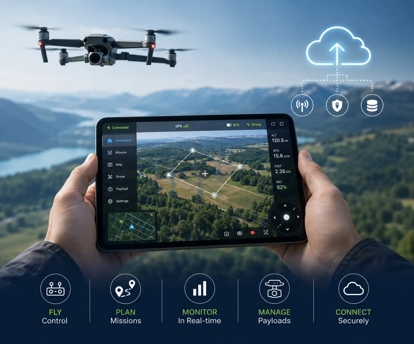
The application for controlling drones offers the possibility of configuring aircraft, planning missions, monitoring activities in real-time, operating payloads, and managing a fleet all on a phone or tablet.
It should communicate properly, provide clear telemetry, react fast, and ensure data protection through local and cloud connections.
With over 10 years of experience in mobile and embedded systems, IoT, AI, cloud and enterprise software, we connect applications to control systems, controllers, cameras, sensors, telemetrics, the cloud and business systems.
Drone Control App Development Services
Drone apps communicate with embedded hardware, display real-time data, manage local state, synchronize with cloud services, and support operational workflows. We design these layers as responsive, secure, maintainable products.
Product Strategy, Architecture, and UX Design
We define the aircraft, users, mission, payload, connectivity, environment, data, safety, and business objectives. Architects specify modules, communication, APIs, offline behavior, cloud services, security, and releases.
UI/UX designers organize controls around pilot priorities. Readable telemetry, meaningful alerts, map-focused workflows, accessible targets, and confirmations reduce confusion in the field.
Native Android Drone App Development
Utilizing different technologies such as Kotlin, Java, Android SDK, Jetpack, WorkManager, Room, Bluetooth, Wi-Fi, location services, and secure storage, we design Android applications that offer direct access to hardware and the handling of background processes.
These applications are compatible with a variety of devices including telephones, tough tablets, controllers, and built-in Android devices with configurable layouts that will adapt for outdoor use, sporadic connection, and prolonged periods of work.
Native iOS and iPadOS Drone Applications
Our iOS engineers use Swift, SwiftUI, UIKit, Core Bluetooth, Core Location, Network, Combine, Keychain, and Apple Maps for responsive iPhone and iPad applications.
We follow Apple's interface and privacy requirements across telemetry, mapping, video, notifications, and field workflows.
Cross-Platform Drone App Development
We create a single codebase for both iOS and Android platforms of your drone application by making use of technologies such as Flutter, React Native, or .NET MAUI.
The technology selection depends on factors such as Bluetooth, video and hardware access, graphics, scale, budget, and roadmap for your project.
Drone Pairing, Onboarding, and Configuration
Apps guide account setup, aircraft discovery, controller pairing, QR onboarding, Wi-Fi provisioning, BLE setup, permissions, activation, and calibration with clear progress and recovery guidance.
Configuration includes aircraft identity, firmware, calibration, networks, payloads, safety limits, return-to-home, and organization profiles with validation against unsupported combinations.
Surveillance of Flights and Monitoring in Real-Time
Dashboards display the flight position, including altitude, velocity, direction, distance, engine state, location, and much more.
Various communication formats might be applied, including MAVLink, MQTT, WebSockets, and HTTPS, that allow for analyzing, buffering, and reconnecting.
Mobile Flight and Payload Controls
Authorized controls can cover takeoff, landing, return-to-home, missions, modes, waypoints, cameras, recording, gimbals, lighting, speakers, sensors, and payload functions.
Command workflows provide state feedback, permissions, confirmations, timeouts, retries, and explanations while distinguishing requests from aircraft-confirmed actions.
Mission Planning and Interactive Maps
Mission tools support waypoints, survey grids, geofences, altitude, speed, payload triggers, points of interest, takeoff and landing, and templates. Users create, validate, approve, upload, and review missions.
We integrate Google Maps, Mapbox, OpenStreetMap, Apple Maps, PostGIS, or enterprise GIS with offline maps, boundaries, terrain, coverage, annotations, and coordinate tools.
Live Video and Camera Management
Apps display real-time video for inspection, mapping, agriculture, construction, and environmental work through playback, adaptive quality, recording, snapshots, overlays, metadata, and camera selection.
Payload controls include zoom, focus, exposure, thermal palettes, gimbal position, capture mode, and storage status. Caching and delayed uploads reduce bandwidth dependence.
Fleet and Drone Management
A business application manages airplanes, pilots, batteries, payloads, locations, missions, repairs, etc., with the help of registrations, assignments, current status, positions, software versions, service intervals, battery cycles, etc.
Role-specific dashboards present the data on utilization, hours of flights, mission efficiency, battery condition, alerts, and maintenance for separate fleets.
Offline Operation and Data Synchronization
Offline-first apps securely store mission plans, maps, checklists, telemetry summaries, inspection results, images, and pending actions when coverage is unavailable.
After reconnection, services upload changes, resolve conflicts, resume transfers, and show what is local, queued, synchronized, or failed.
Cloud Backend and Administrative Portals
The backend manages the authentication of users, organizations, aircraft, missions, telemetry, media, notifications, subscriptions, and analytics. Portals assist in managing visibility of fleets, permissions, configuration, support, and reporting of data.
The tech behind the portals can be AWS, Google Cloud, Azure, Firebase, Kubernetes, or proprietary infrastructures incorporating .Net, Java, Node.js, Python, REST, GraphQL, WebSockets, and MQTT technologies.
Alerts, Notifications, and Operational Workflows
Alerts cover battery, communication, GPS, geofences, sensors, mission changes, maintenance, weather, and completed processing. Push notifications inform supervisors when attention is required.
Digital checklists, approvals, issues, inspection forms, signatures, notes, and photo evidence create traceable workflows.
Safety, Functions, and Information Security
We apply OAuth 2.0, JSON Web Tokens (JWT), MFA, biometric recognition, role based access control, encryption, certificate authentication, secure storage, Keychain and other security features, session management, and auditing.
The system provides the roles of pilots, operators, administrators, customers, technicians, and supervisors and restricts access to data by organizations, planes, places, and resting activities.
Edge AI and Computer-Vision Integration
Apps display NVIDIA Jetson, Raspberry Pi, NXP i.MX, or companion-computer results including detection, tracking, segmentation, inspection findings, anomalies, crop analysis, landing zones, and navigation assistance.
We integrate TensorFlow, PyTorch, ONNX, TensorRT, DeepStream, and OpenCV. Apps overlay detections, organize findings, notify operators, and synchronize verified results.
Firmware and Software Update Management
Apps check versions, download signed packages, transfer updates, monitor progress, verify integrity, and confirm restart for flight controllers, payloads, telemetry modules, and companion computers.
Staged releases, compatibility checks, recovery, retries, rollback, and fleet deployment status reduce update risk.
API and Integration of External Services
We link various applications with ERP, GIS, asset management, maintenance, construction, agriculture, logistics, identity, weather and reporting through REST, GraphQL, webhooks, SDKs, queues and synchronization. The flow of information related with missions, locations, findings, work orders, assets, media and reports through business processes is performed without duplicate data input.
Testing for Mobile Applications and Ensuring Quality
Testing involves multiple areas such as device type, operating system versions, permissions, Bluetooth, Wi-Fi, mobile network, APIs, GPS maps, video, background operation, offline operation, synchronization, battery consumption, performance, usability, and security.
Unit testing, integration testing, UI testing, regression testing, load testing, field testing, testing on different networks, testing for prolonged sessions and device-specific testing uncover defects before release.
Deployment and Long-Term Maintenance
Our services include preparation of applications for App Store and Google Play, signing, privacy information provision, staged rollout, crashed applications monitoring and support, production launch, and private distribution.
We offer compatibility and optimization processes, security patches updating, SDK updates, diagnostic capabilities for our applications, and support for hardware and cloud services after application launch.
Our Drone Control App Development Process
Each particular interaction starts with discovery workshops that discuss aircraft features, user roles, data, safety expectations, connectivity, maps, and payloads.
Discovery & Requirements Gathering
We transform all of these findings into user journeys, interface specs, protocol agreements, acceptance criteria, and a phased delivery plan.
Interactive Prototyping
Interactive prototypes allow for the validation of navigation and telemetry hierarchy, alerts, and control placements before implementation.
Incremental Development & Testing
Development then proceeds through incremental releases that connect real devices, simulated aircraft, backend services, and representative field workflows.
Source control, peer review, automated testing, documented APIs, test builds, analytics, and release notes keep quality visible throughout delivery.
Pilot Feedback & Refinement
Pilot feedback helps make improvements before launching the product publicly or to an enterprise.
Launch & Ongoing Support
The approach allows delivering fixed-scope products through dedicated teams, modernization or updates, and further development of functionalities without compromising architecture consistency and operational traceability in case of cloud and mobile releases.
Drone Mobile App Technologies We Use
| Category | Technologies |
|---|---|
| Mobile | Kotlin, Java, Swift, SwiftUI, Flutter, React Native, .NET MAUI |
| Drone and IoT | MAVLink, PX4, ArduPilot, MQTT, WebSockets, BLE, Wi-Fi, cellular, GPS/GNSS, custom protocols |
| Maps and Media | Google Maps, Mapbox, OpenStreetMap, Apple Maps, PostGIS, WebRTC, platform video frameworks |
| Backend and Cloud | .NET, Java, Node.js, Python, AWS, Azure, Google Cloud, Firebase, Docker, Kubernetes |
| Data | PostgreSQL, SQL Server, MySQL, MongoDB, Firebase, Room, Core Data |
| AI and Vision | TensorFlow, PyTorch, ONNX, TensorRT, NVIDIA DeepStream, OpenCV |
Drone Control Applications We Develop
Our mobile solutions support industrial inspection, agriculture, mapping, surveying, construction, utilities, environmental monitoring, warehouse operations, emergency response, security patrol, delivery trials, media production, and autonomous commercial UAVs.
Industrial Inspection
Agriculture
Mapping & Surveying
Construction
Utilities
Environmental Monitoring
Warehouse Operations
Emergency Response
Security Patrol
Delivery Trials
Media Production
Autonomous Commercial UAVs
Create Your Own Drone Control Application with Us
If you are looking for a specialized pilot application, commercial fleet application, operation planning program, video application, or full mobile and cloud platform, Adequate Infosoft can assist you.
Tell us about your drone platform, communication method, functionality specifications, and/or available mobile application and we will formulate the optimal strategy from the discovery and UX design to development, testing, implementation, and support.